


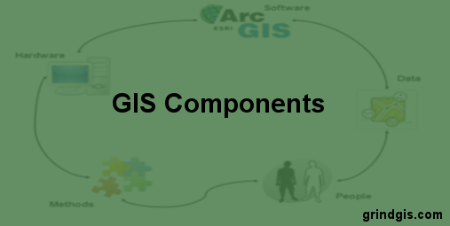
Geographic Information Systems (GIS) have revolutionized how we perceive and interact with spatial data. In today’s interconnected world, GIS plays a pivotal role in various fields, from urban planning and environmental management to disaster response and marketing. To understand the magic behind GIS, it’s crucial to delve into its key components, each contributing to the power and versatility of this technology. In this article, we’ll explore five fundamental components of GIS and shed light on their significance in shaping our modern world.
Spatial Data
To begin with, at the heart of GIS lies spatial data, the foundation upon which the entire system is built. Spatial data is comprised of points, lines, polygons, and raster images, all meticulously representing geographical features. These data sets, ranging from maps to satellite imagery, are vital for making informed decisions. Spatial data serves as the canvas on which GIS professionals paint their insights, helping them visualize, analyze, and interpret complex patterns within our environment. Whether you’re tracking the movement of a hurricane or planning a new city park, spatial data is the cornerstone of GIS applications.
GIS Software
Additionally, while spatial data provides the canvas, GIS software is the artist’s brush. These specialized programs allow users to manipulate, analyze, and visualize spatial data. Widely-used GIS software such as ArcGIS, QGIS, and Google Earth Pro offer an array of tools to perform tasks such as map creation, geocoding, spatial analysis, and data modeling. Hence, with user-friendly interfaces and powerful algorithms, GIS software empowers professionals in diverse fields to harness the potential of spatial data for better decision-making.
Hardware
In addition, behind every great GIS operation is a robust hardware infrastructure. Hardware components, including computers, GPS devices, and servers, ensure that GIS systems operate seamlessly and efficiently. High-performance computers are essential for processing large datasets and running resource-intensive GIS software. GPS devices provide precise location data, enabling real-time tracking and accurate mapping. In addition, powerful servers and storage systems are vital for managing and storing vast quantities of spatial data. Moreover, as technology advances, so does the capacity of GIS hardware, enabling more sophisticated applications and analyses.

People
Even with the most advanced software and hardware, GIS would be incomplete without the expertise of skilled professionals. Hence, people are the driving force behind GIS, from data analysts and cartographers to GIS developers and urban planners. These individuals possess a deep understanding of geography, data analysis, and spatial modeling. Their ability to interpret and communicate spatial patterns is crucial in solving complex problems, whether it’s optimizing supply chains or mitigating the impact of natural disasters. Therefore, in essence, people are the architects of GIS applications, translating data into actionable insights.
Data Sources
To add on, the quality and reliability of spatial data are heavily reliant on the sources from which it is derived. GIS draws data from various sources, including remote sensing technologies, government agencies, surveys, and crowdsourcing. Remote sensing, through satellites and aerial imagery, provides up-to-date information on land use, weather, and environmental changes. Government agencies offer valuable data on demographics, infrastructure, and public services. Surveys and fieldwork contribute ground-truth data, adding depth to spatial analyses. Moreover, crowdsourced data, gathered from platforms like OpenStreetMap, harnesses the collective knowledge of users worldwide to improve GIS accuracy and completeness.
Conclusion
In conclusion, in today’s data-driven world, Geographic Information Systems have become indispensable tools for informed decision-making. The five components of GIS—spatial data, GIS software, hardware, people, and data sources—work in harmony to create a comprehensive and dynamic system. Spatial data serves as the canvas, GIS software the brush, hardware the canvas holder, people the artists, and data sources the inspiration. Together, they enable us to unlock the secrets of our environment, tackle complex challenges, and shape a better future.